Road trip on the main island
- Coralie & Salah

- Jun 22, 2020
- 5 min read
May 27 to June 3rd, 2020
We’ve been in Noumea for about 3 months now and as things settled down after Covid 19 crisis, we just appreciated living life here. We have taken day trips around, went to the beach, enjoyed snorkeling to see the marine life but apart from our two-day trip to Bourail, we had stopped our travel routine for a while.
Initially, we were supposed to stay only 2 weeks in New Caledonia, one week in Noumea and one visiting the north of the main island.
On May 27, we decided it was about time to hit the road and go on that trip.
Geography bubble: New Caledonia is divided into 3 provinces, the South (where Noumea is located that and concentrates more than 75% of the population), the North and the Loyalty islands (Lifou, Ouvéa, Maré). The North and South provinces make up the Main Island.
Here is our trip itinerary

Koumac
Located 370 km (230 miles), 4.5 hour drive from Noumea, Koumac is a small town (less than 4,000 people), in the north west of the island.
We stayed for 2 nights at the "Gîte du Lagon" in a hut inspired by the traditional kanak architecture (link).


We mostly came here to visit the Tiébaghi mine (link), a chrome mine in the mountain that operated until 1990.
Geology bubble : The mineral resources (chrome, copper, nickel) of New Caledonia have been the basis of the territory's economy. New Caledonia's soil contains about 25% of the world's nickel ressources, the island is the second nickel exporter in the world.
The Tiébaghi chrome deposit was discovered in 1877 and the exploitation started in 1901. A whole village with school, church, hospital, bakery was then created on the spot and workers lived there with their family. At its peak in the 1950s, the village counted 7,000 people.
In 1962, after a social conflict between the French government and the mine directors, it was decided to close the exploitation. People believed it was a temporary decision and left their houses thinking they would come back anytime soon. It never happened and the city remained abandoned.
In 1981, Inco, a Canadian mine company found out about the resources there and bought the place. The miners and their families were living down the mountain though so the village was never inhabited again. They exploited it until 1990 and left when nothing could be extracted anymore.
Unlike current practices, it was not mandatory at the time to reforest the site. The mountain was left as is, creating ecological problems such as erosion. It is just recently that some projects of replanting trees have been implemented while maintaining the site for historical and patrimonial purposes.
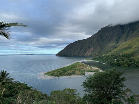
Here are some pictures of the landscapes around the mine

Poingam
Located 70 km north of Koumac, Poingam is actually the northernmost place on New Caledonia main island.
As soon as we arrived to our guesthouse (Kejaon, https://kejaon.wordpress.com), we fell in love with the place. The guesthouse was located on the beach and the view was amazing: white sand, clear blue water. We spent 2 nights there, one in a rustic room, the second one in 2 tents (the room was not available for 2 nights). It was the first time the girls experienced real camping and they were thrilled about it (a little less when we had rain in the evening though).
To give you an idea, here is the view from our room

We spent 2 days, chilling on the beach, snorkeling and, kayaking on the bay. The girls played all day long with the 2 owner's children. We also went to the Relais de Poingam (link), a famous guesthouse and restaurant located at the end of the road at the very north.
And a beautiful sunset from our guesthouse

Hienghène
Located on the east coast, Hienghène is the most touristic place in the North Province and is known for the ‘’Poule”, a hen-shaped limestone rock formation.
To get there, we crossed the island from west to east, going through the Col d’Amos, a mountain pass where we could see the island coast-to-coast.
West and east coasts of the Main Island
Coming from Poingam and taking the transverse road Koumac-Pouebo, we had to cross the Ouaïème river. However, there is no bridge there and the only way to cross the water is to take the last New Caledonia steel ferry. The car and passengers all go on the floating platform and we just have to wait until we reach the other side. As you can see, the landscape here is magnificent and it is enjoyable to take time to contemplate it.
History bubble: In Coralie's grand-father's memoir (he used to be the General Manager of Public Works in New Caledonia from 1967 to 1973), he mentions his mission to build bridges (getting rid of all ferries) on the numerous rivers of the east coast in the 60s to the exception of the Ouaïeme river as a way to preserve the history of our island.
Culture bubble: In the Kanak people spirit, this place is sacred as it represents the entrance to the land of the dead. (source)
The Ouaïème river
On the ferry
This time, we treated ourselves and rented a very nice room in a resort, the Koulnoué Village. Many activities were available for the kids and we played mini-golf, tennis, table soccer and played in the pool. Coralie and I enjoyed a drink while the kids were playing with other kids in the evening, which was pleasant.
Swimming pool, mini-golf, tennis and breakfast on the beach
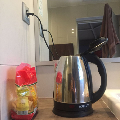
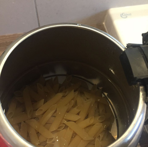
During our trip, we cooked with whatever we had access to: microwaves, stoves. In Koulnoué village though, we only had a kettle at our disposal. So we got creative. Who would have thought that pasta can be cooked in a kettle? 😃 During our trip, we also tried the local tables in Poingam and Hienghène and had wonderful meals.
Google it if you want the recipe... it works! 😜
We booked a snorkeling tour with Babou Coté Océan (link) nearby. We took a boat to an islet 20 minutes away, had a botanic tour with our guide and then the four of us put on our flippers, masks and snorkels and swam about an hour in the clear blue water right off the islet. The whole north-east lagoon is classified by the UNESCO. It was incredible, we saw hundreds of colorful fish, and corals. The spot (as many sites in New Caledonia) is amazing and compares with scuba diving sites. Unfortunately we are not equipped with waterproof cameras to show you some pictures. However, while it was drizzling in Hienghène, the weather was sunny on the islet!
And of course, we went to some nice viewpoints of the Nesting Hen. Looks totally like it but 100% made by nature.


After a very nice week on the road, we headed back to Noumea. On our way back, we stopped in a war memorial on the Gaïacs plain, where the US built a temporary military airbase in 1941 (2 runways in a record time). The crossing runways can still be seen in the plain. This place is a testimony of the important role of New Caledonia as a US military base in the Pacific Ocean during WW2.

Salah


Comments